- 30 May 2021
- Posted by: Zakaria
- Categories: Business, Press releases
Not long ago marks the availability of ArcGIS Enterprise 10.9 as part of the ArcGIS 2021 Q2 release! This release is full of enhancements and new functionality across many areas of the product. In this blog, we will cover a number of key features across content and data management, the ArcGIS Enterprise portal, administration, and more.
Furthermore, keep a lookout on the ArcGIS Blog site for additional articles covering specific features in-depth. More info provided by Esri about their ArcGIS Enterprise blogs
1. Content and data management
1.1. Shared editing using distributed collaboration
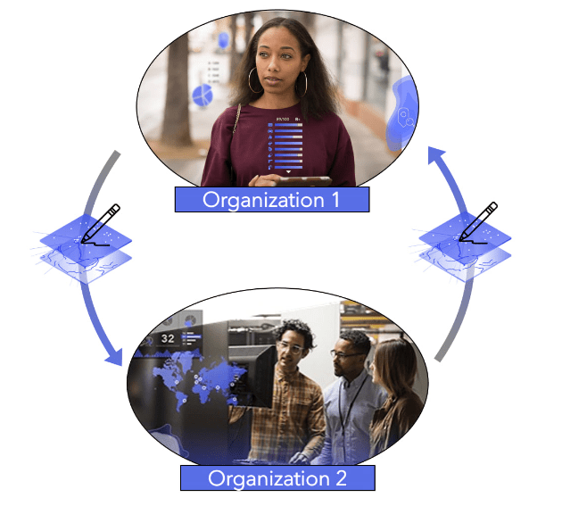
For many years, organizations have been using distributed collaboration to share layers, maps, and apps with other ArcGIS Enterprise and ArcGIS Online environments, facilitating better access to data and content and new ways of working together. With this release comes an exciting new collaboration enhancement enabling organizations to edit and synchronize data updates across environments. Previously, only the organization that originally owned the layer could sync edits. Now, two-way syncing is possible.
This has been a highly requested feature in order to streamline data management workflows and help teams work more closely together. Organizations have shared with us that they plan to use this for field data collection across Enterprise and Online, to contribute to source of truth datasets across departments, and much more. Learn more about this feature in an upcoming blog and the share content with collaboration groups documentation topic.
1.2. Group export/import update
At ArcGIS Enterprise 10.8.1, two new REST resources were introduced, /export and /import, to make it easier to move content across development, staging, and production environments. Used together, these resources take the content in a group (layers, maps, and apps) and export them into a package that can be imported into another ArcGIS Enterprise deployment. This process can be done through REST and scripted using the ArcGIS API for Python. Starting with this release, you can now choose to import your content into a specific folder. This avoids having to add items into a folder after the import operation and saves time.
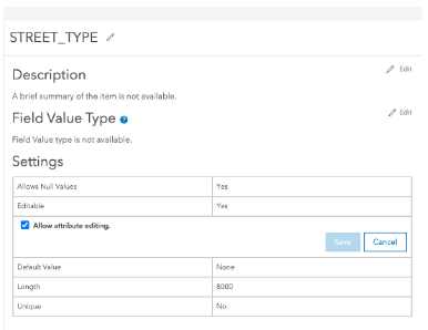
1.3. Field-level editing settings
Field-level editing settings allow you to disable editing on certain fields in your editable hosted feature layer. Say you have a layer that includes green roofs (vegetated roofs) on commercial properties in your city. You’d like to enable editing on the layer so that attributes about the roof can be updated, but you wouldn’t want key fields like the building address to be edited. With this setting, you can enable editing on the layer and then disable editing on the specific address field.
1.4. Append data
As new data comes in and is available, there may come a time when you need to append data to an existing hosted layer. With this update, this is now possible using append, where you can add features to your layer or update existing features. Supported formats for appending data include shapefiles, CSVs, Excel sheets, and GeoJSON files.
1.5. Join Features to a view
Following along the data management theme, many users have asked for the ability to create a joined layer that dynamically updates as the input layers do. To achieve this, you can now run the Join Features analysis tool and set your output to be a hosted feature layer view. The hosted feature layer view will be read-only and will update as your input layers change to reflect the most recent data.
For example, using a layer of green roofs on commercial properties, I could run the analysis tool Join Features to combine attributes from another layer that contains other information about the property—perhaps the year it was benchmarked for energy usage and the date it was constructed. This gives me a result layer with an even more comprehensive understanding of the characteristics of the property. By creating a hosted feature layer view, if an attribute changes, such as the size of the green roof in the green roof layer, this will be reflected in my view so that I do not have to run Join Features again to get the most up to date data.
1.6. Simultaneously publish a vector tile layer and associated feature layer
Now using ArcGIS Pro 2.8 you can publish a vector tile layer and an associated feature layer simultaneously! You will now see this option when sharing a web layer from ArcGIS Pro.
With this new option, editors can update a feature layer with new features and once they are done, you could then rebuild the vector tile cache through the ArcGIS Enterprise portal. This means the edits would be reflected in the vector tile cache layer so any map where this vector tile cache layer is present is now also up to date.
2. ArcGIS Enterprise portal
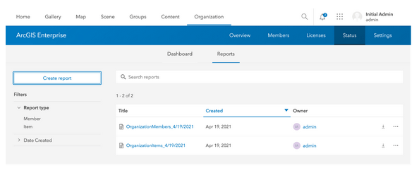
2.1. Administrative reports
Administrative reports are one of the new features in ArcGIS Enterprise that I am most excited about. These exportable reports have lots of potential when it comes to helping administrators better understand their environments and act on that information. Under Organization > Status > Reports in your Enterprise portal, there are two types of reports that can be generated: member and item. The member report lists various attributes about members in your organization such as username, name, email, profile visibility, user type, last login, and group and item ownership. With member reports, you can answer questions such as:
-
-
- Which users have or haven’t logged in this month?
- Which users own the most items?
- How many new users were created this year?
- How many Creator user types are in our organization?
-
The item report lists all items in your organization and information about them such as the item type, the date created and last modified, the number of views, owner, sharing settings, and tags and categories. With the item report, administrators are able to tell:
-
-
- What kinds of tags are being used and where are there similarities and redundancies?
- How many views has this item received? (Plus, by exporting this report on a schedule, you can use this to track views over time.)
- Which items are not using content categories?
- Which items are not shared with anyone?
- Which items have not been modified in the last year?
- Which items have similar titles?
-
These are just a few examples of the many questions you can answer using the member and item reports. Reports can be exported by members with the default administrator role and downloaded to a CSV for further analysis and integration with other business systems. For more on admin reports, see the related blog: What’s New in ArcGIS Enterprise 10.9: Administrative Reports.
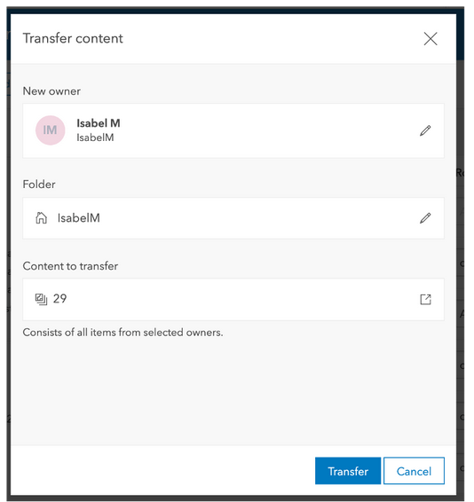
2.2. Bulk transfer items
There is now a new operation available that allows admins to quickly and easily transfer content from one owner to another. From Organization > Members in your Enterprise portal, you can select one or more members and then select the option transfer content. This will move all content to the new owner and is very helpful when you need to transfer content in bulk.
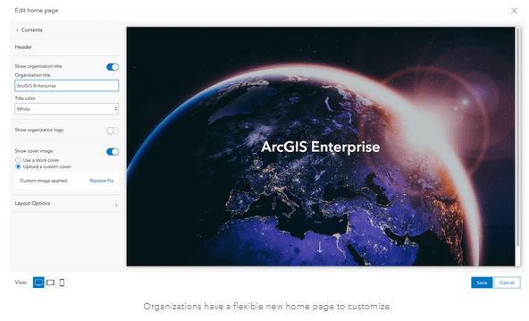
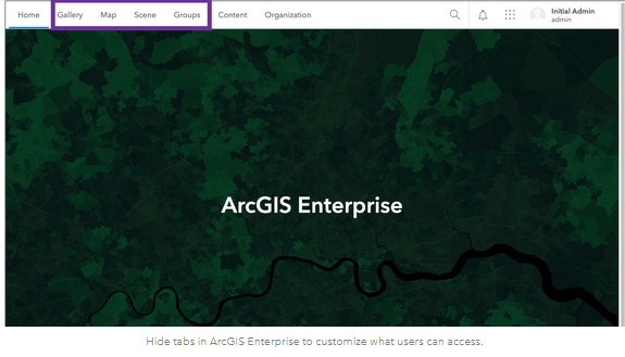
2.3. Brand new navigation system
This release introduces a new home page configuration experience. This new home page editor is component-based, optimized for accessibility, and mobile, desktop, and tablet friendly. It includes the ability to add website and email links in the body text and in item gallery summaries. New is the ability to specify who can access certain tabs within the Enterprise portal. Tabs that can be hidden include gallery, map, scene, and groups. An example of where this is helpful is as an administrator, you can make the Groups tab only visible to organization members, meaning it won’t show up for anonymous users visiting the ArcGIS Enterprise portal. Similarly, you can hide the map and scene tabs for everyone but those users who are able to create maps and scenes. Maps and scenes will still be able to be opened by other users, they just won’t see the tab.
2.4. ArcGIS Solutions app
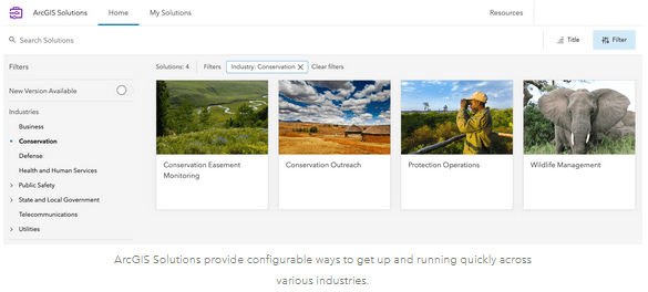
In the May/June 2021 timeframe, the ArcGIS Solutions app will be available for ArcGIS Enterprise 10.9. This app is a way to quickly deploy solutions directly into ArcGIS Enterprise and will be made available as a separate install. Once the ArcGIS Solutions app is installed, it can then be accessed through the app launcher at the top right of your Enterprise portal. Here you can browse through the solutions, search for a specific solution, or filter the gallery to quickly find a solution. Once you discover a solution you are interested in, the information panel will provide an overview of the solution and an option to deploy it.
3. Administration
3.1. OpenID connect
Starting with this release of ArcGIS Enterprise, administrators can now set up OpenID Connect logins to allow members to sign into ArcGIS Enterprise using the same username and password they use to sign into their organization’s OpenID Connect-based login system.
3.2. Multifactor authentication
With this release, ArcGIS Enterprise includes the ability to enable multifactor authentication for built-in ArcGIS Enterprise accounts. This option provides an extra level of authentication at sign-in by requesting a verification code, commonly sent to your mobile phone, in addition to the username and password you traditionally provide. Multifactor authentication can be set up using the authentication provider of your organization’s choice. The options for OpenID connect and multifactor authentication are pictured below:
3.3. Updated experience for configuring emails
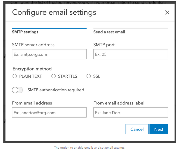
In the last release, we introduced the ability to send emails from the ArcGIS Enterprise portal. This new feature was helpful for a multitude of reasons—such as when a member of the organization forgets their password and needs a temporary password reset link sent to them, or when your portal license is expiring. In order to configure emails, ArcGIS Enterprise is integrated with your organization’s SMTP server.
Previously, email settings are configured through the Portal Administrator Directory. Now beginning at this release, emails can be configured directly within the ArcGIS Enterprise portal. This release also includes new email-driven workflows, such as notifications when the disk space is low on your portal machine, when items receive comments, and when profile settings are updated.
4. Apps
4.1. ArcGIS Field Maps included with ArcGIS Enterprise install
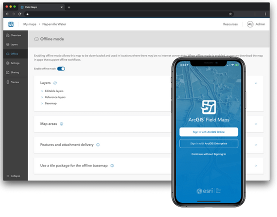
ArcGIS Field Maps is a new app that was introduced last year. It that allows you to streamline field workflows and take maps anywhere. Mobile workers can use Field Maps to explore the maps you make in ArcGIS, collect and update data, and track their location—all from one app! In previous versions of ArcGIS Enterprise, Field Maps was a separate install in addition to ArcGIS Enterprise. Starting in 10.9, ArcGIS Field Maps is now included with ArcGIS Enterprise by default, no separate installation necessary. For more information on ArcGIS Field Maps, see the ArcGIS Field Maps documentation.
4.2. Map Viewer Beta
The new Map Viewer was first available as a beta at the ArcGIS Enterprise 10.8.1 release. At ArcGIS Enterprise 10.9, the new Map Viewer will be available in a beta capacity as well. For more information on installing the beta, visit the Map Viewer Beta in ArcGIS Enterprise 10.9 blog.
We encourage ArcGIS Enterprise organizations to try out the new Map Viewer! A few of the key capabilities include new symbology styles such as dot density, improved color ramps, the ability to group layers, new clustering functionality, dynamic filtering, enhancements to pop-ups, and much more.
4.3. ArcGIS Enterprise Sites updates
ArcGIS Enterprise sites are a great way to showcase your maps, data, and apps to a wide audience using tailored websites and pages. There are many new features in ArcGIS Enterprise Sites. These new features include the ability to:
-
-
- Control the visibility of your sites and pages and grant edit access to select groups with redesigned sharing options.
- Brand your site’s sign in prompt with a theme and logo set in the enterprise organization settings.
- Set the visibility of a row on a site or page to limit content to select groups.
- Create drafts of sites and pages prior to publishing your changes.
- Send a preview link of a draft version of a site or page to others.
-
For more, be sure to take a look at what’s new in ArcGIS Enterprise Sites.
4.4. ArcGIS Experience Builder updates
Introduced in the last release of ArcGIS Enterprise, ArcGIS Experience allows you to create unique web experiences using flexible layouts, content, and widgets that interact with 2D and 3D data. New features for ArcGIS Experience Builder in ArcGIS Enterprise include:
-
-
- The ability to set font and background color of legend.
- The ability to set auto refresh interval on embedded content.
- The following new widgets: card, bookmark, divide, table, and branch version management.
-
To see what all is new for ArcGIS Experience Builder at this release of ArcGIS Enterprise, check out what’s new in ArcGIS Experience Builder.
4.5. ArcGIS StoryMaps updates
ArcGIS StoryMaps is a simple map making application that enables you to create custom maps to enhance your digital storytelling. Updates to ArcGIS StoryMaps in ArcGIS Enterprise include:
The new explore map tour block, which allows for users to browse large sets of places in grid or list view.
-
-
- The ability to create a map tour by uploading photos.
- Support for audio in line blocks and sidecar.
- The ability to geolocate map tour places through photo geotags.
-
For more information on ArcGIS StoryMaps, take a look at what is ArcGIS StoryMaps.
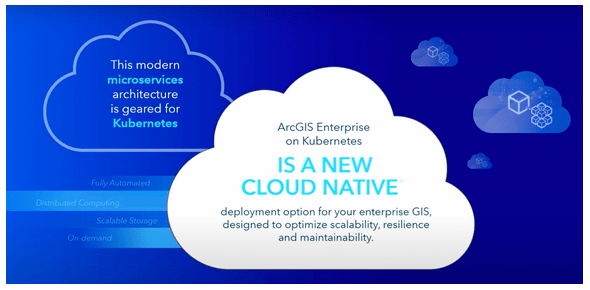
5. Introducing ArcGIS Enterprise on Kubernetes
ArcGIS Enterprise on Kubernetes is now available, Esri’s new cloud-native deployment option for ArcGIS Enterprise based on microservices and containerization! This deployment option is optimized for scalability, maintainability, and resiliency, and is managed and orchestrated using Kubernetes, an open-source system for automating deployment, scaling, and management of containerized applications.
ArcGIS Enterprise on Kubernetes is another deployment option, offered in addition to the current deployment methods of Windows and Linux. If you are interested in Kubernetes and this new deployment option, please have a conversation with your Esri representative. For more information on ArcGIS Enterprise on Kubernetes, visit the Kubernetes blog series on the blog site.
This concludes an overview of some of the key features and capabilities in this release of ArcGIS Enterprise! For a comprehensive look at everything included in this release visit the What’s new in ArcGIS Enterprise help topic and associated subtopics. Also visit the What’s New in ArcGIS Enterprise 10.9 video:

Aldaleel Raqamee Partnership with Esri
How does registration work?
Registration is complimentary for everyone. You only need an Esri Account with a unique email address to sign up—create an account at any time for no cost. If you are not up-to-date on your subscription or maintenance, you will have access to the Plenary Session only.
General attendance
You will get access to the full conference if you are current on your maintenance plan or subscription, including users with ArcGIS for Personal Use licenses, distributors and partners.
Student
You will get access to the conference if you are a current student or 2021 graduate. Access to the Expo and Esri Showcase requires you to be an Esri customer.
Plenary Session access only
Jack Dangermond’s keynote, followed by other thought-provoking speakers, highlights how GIS is making a difference in the world. Learn from demonstrations of Esri technology and get news about the newest upgrades.
Check our latest available blogs

Experience the Thrill with Claw Grab Machine
Experience the Thrill with Claw Grab Machine Are you ready for an exhilarating adventure? Look no further than the claw grab machine! This exciting game will test your skills and bring out your competitive spirit. Get ready to dive into a world of excitement and anticipation as you try to grab that coveted prize! The
ملتقى ومعرض ليبيا الدولي للإتصالات وتقنية المعلومات Taqnya
“Aldaleel Raqamee for IT & GIS” شركة الدليل الرقمي لتقنيـة المعلومات والنظم

Esri User Conference
Your Virtual Conference Seat with Esri The 2021 Esri User Conference (Esri UC) is a fully virtual experience provided by Esri. Aldaleel Raqamee Company is one of Esri's partners and as a virtue of goodwill. We would like to invite you to join Esri's virtual conference. Join Esri's conference on July 12–15, 2021. The plenary